Boise Peak Powder
- Details
The skiable vertical of Boise Peak is under 1000 feet. Half of that is in the trees. The top half -- the limelight -- is a giant open glade of virgin powder. A slope that has only been skied a few time in history. Unbelievable.
Is it worth the 15 mile approach? When a skier has made the first leg of the approach and crosses the Eagleson Summit and sees the 10-mile-vista of pure downhill stretching out to Boise like a white carpet, what happens to his resolve to continue the remaining uphill mile to the Summit of Boise Peak? {mosmap msid='203308469576360246271.000445969f1f097409027'|width='250px'|height='250px'}
Since it is so close, it should be a simple thing to ski out and back to Boise Peak and get that untracked powder. But it's not that simple. Boise Peak is five snowbound miles of wilderness from the top of Deer Point. Seemingly as distant as the Bugaboos. Returning to Bogus is five miles of uphill on an exposed slope. The easy solution would be to continue the remaining 10 miles down to Boise. But snow in Boise is a reason to celebrate, perhaps once or twice a year. Snow enough to ski from Boise Peak to Boise is rare indeed. Is it Global warming? No Boise lies in the Idaho Banana Belt at a lowly 2700 feet. In Idaho 2700 feet is considered tropical. So when there's snow, it's time to move.
Even though it's almost all downhill it's no sleigh ride. There may be snow, but it's not the Bugaboos. It's the BogusBoi. The snow is fine at the top but towards the bottom it is slush, or worse, set snow. Snow that has been frozen and melted and frozen again. And it's thin. Just enought to cover last summers wheat grass. Crank our a hard turn and you will be pushing tracks through the famous sand loam of the Boise Front.
The route is mostly downhill. Where the route crosses the flanks of Boise Peak it climps a couple miles of mild uphill. After Eagleson Summit, another mile of uphill remains to reach the Boise Peak summit. From there 900 vertical feet of untracked powder fields are waiting. Untracked powder and untouched terrain. I've seen tracks on this peak once in my life. I've made tracks on this peak twice. A long hike. A long day for perhaps 20 turns. Is it worth it?
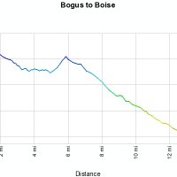
The Route
- Deer Point 7050'
- Boise Peak 6500'
- Eagleson Summit 6088'
- Camels Back Park: 2740'
- Distance:15 miles
- Vertical drop: 4310'
Packing List
- AT equipment
- Lunch
- shovel
- peeps
- map
- Water
The Plan
- 7 am meet Sunday
- 7 am set shuttle
- 9 am arrive bogus.
- 11 am arrive Boise Peak
- 12 ski Boise peak
- 2 ski to Boise
- 5 Harry's Tavern